It wasn’t until the modern era that would-be conquerors and do-gooders could think on a global scale. The discovery of the New World and the invention of steamboats, the telegraph, airplanes, television and intercontinental ballistic missiles made the world feel smaller. Egyptian pharaohs and Chinese emperors may have claimed to rule everything under the sun and the heavens; it wasn’t until the nineteenth century that an island nation on the western edge of Eurasia could acquire an empire on which the sun never set.
The potential of world conquest inflated the ambitions of political movements. Marxists called for a world revolution of the proletariat. Fascist Germany and Japan planned to divide the world between them. America sought to make the world safe for democracy.
If world war and world conquest were possible, then surely so were world peace and unity? Pan-Europeanism and internationalism flourished in the twentieth century, giving life to the League of Nations, the United Nations and what would become the European Union.
From the 1494 Treaty of Tordesillas to the would-be EUs of the present day, here’s a history at attempts — few of them successful — to remake the world.
Treaty of Tordesillas
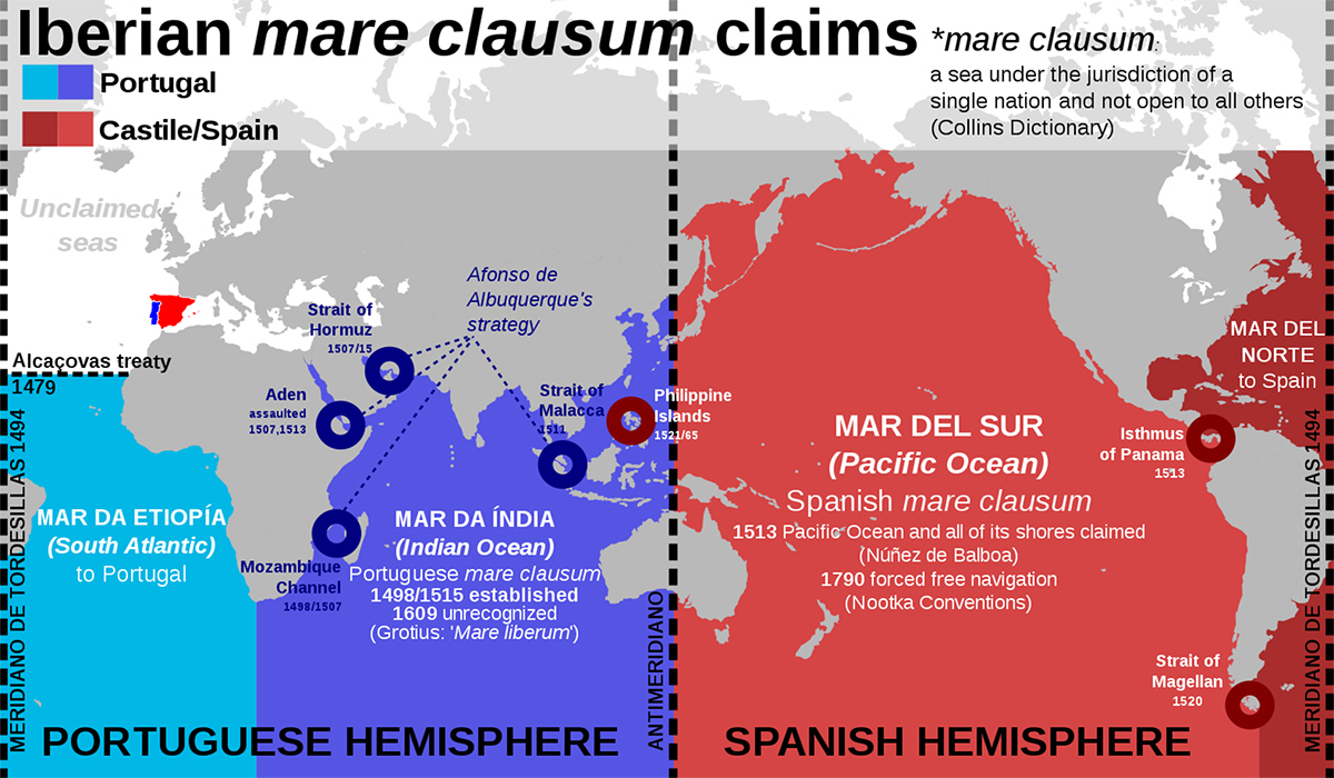
The 1494 Treaty of Tordesillas, which divided up the world outside Europe between Portugal and Spain, was the first attempt by two nations to reorder the entire world without resorting to war between them.
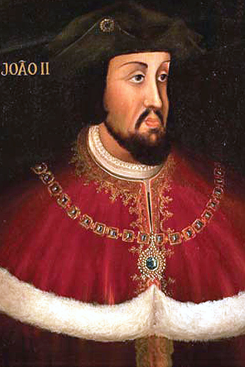
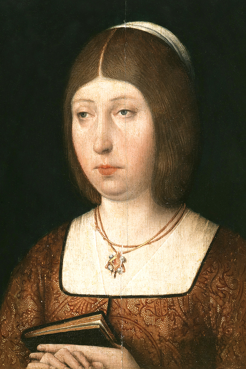
The Spanish monarchy had funded Christopher Columbus’ journey to what would become known as the Americas, however, Portugal had a claim to all lands south of the Canary Islands ratified by the pope. King John II of Portugal meant to make good on that claim. His Spanish counterparts, King Ferdinand or Aragon and Queen Isabella of Castile, did not have the military wherewithal to challenge him. So they sought a diplomatic solution, appealing the Spanish-born Pope Alexander VI, who decreed in 1493 that all lands west of the Azores and Cape Verde should belong to Spain.
John half-agreed. He insisted that Portugal should explicitly be given a free hand east of the line. Hence the Treaty of Tordesillas, which gave Portugal Africa and India — and, it turned out, a slice of Brazil. That’s how Brazil became a Portuguese colony, and Portuguese-speaking, while the rest of Latin America fell under Spanish sway.

Other European powers, which colonized North America, ignored the treaty. Native American populations weren’t consulted. Portuguese and Spanish leaders barely even knew of the people of the New World when they carved it up.
The 1529 Treaty of Zaragoza drew a similar line on the other side of the world, which would have given Spain a slice of Australia, which it never colonized, but not the Philippines, which it did.
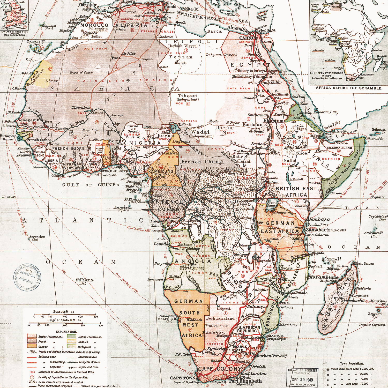
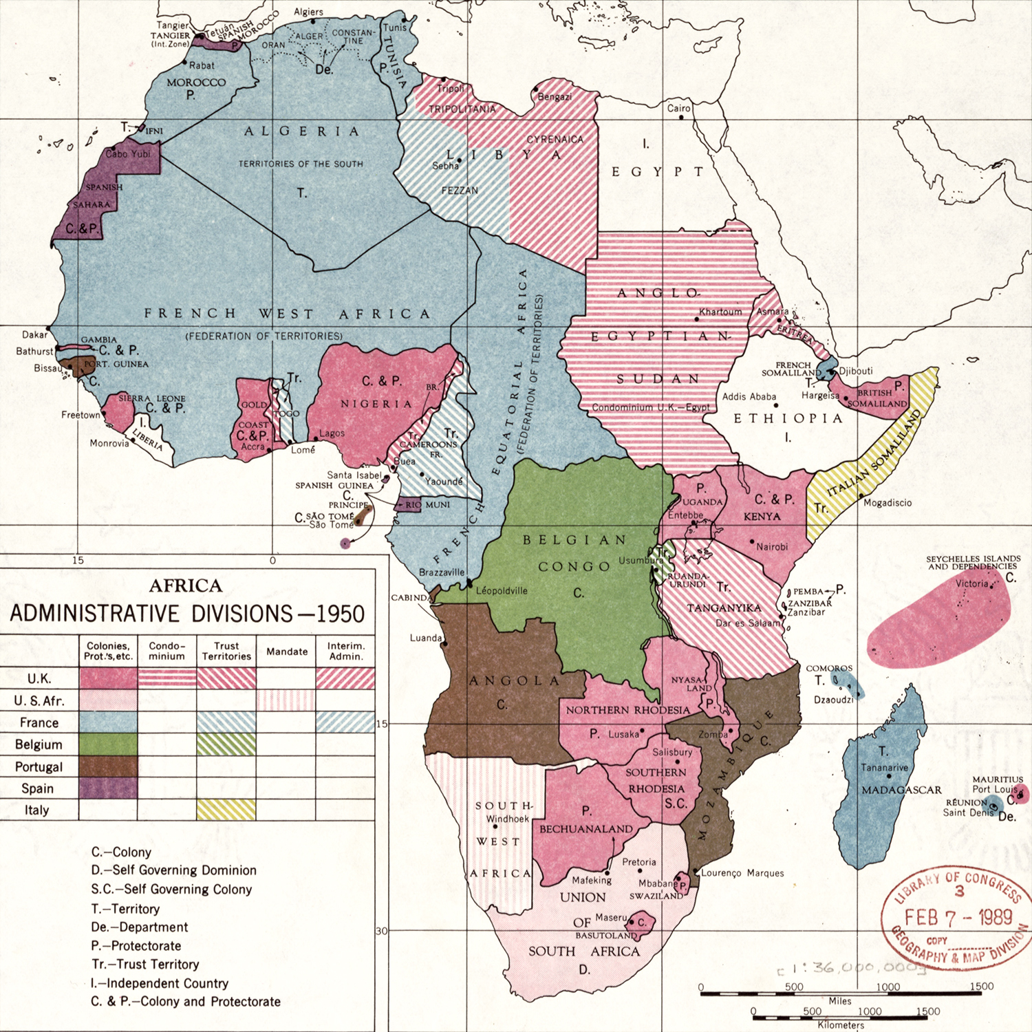
Berlin Conference
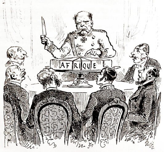
At the height of the imperial era, Otto von Bismarck, the first chancellor of the united Germany, invited his European counterparts to Berlin to resolve a dispute between Belgium, Britain, France and Portugal over control of the Congo. Other territorial disputes were resolved at the same conference, so that it effectively formalized the Scramble for Africa.
In the years after the conference, the European powers consolidated their rule over the dark continent, largely without fighting each other. Just 10 percent of Africa had been colonized in 1870. By 1914, Europeans claimed 90 percent of Africa, with only Ethiopia and Liberia remaining independent.

Morgen die Ganze Welt!
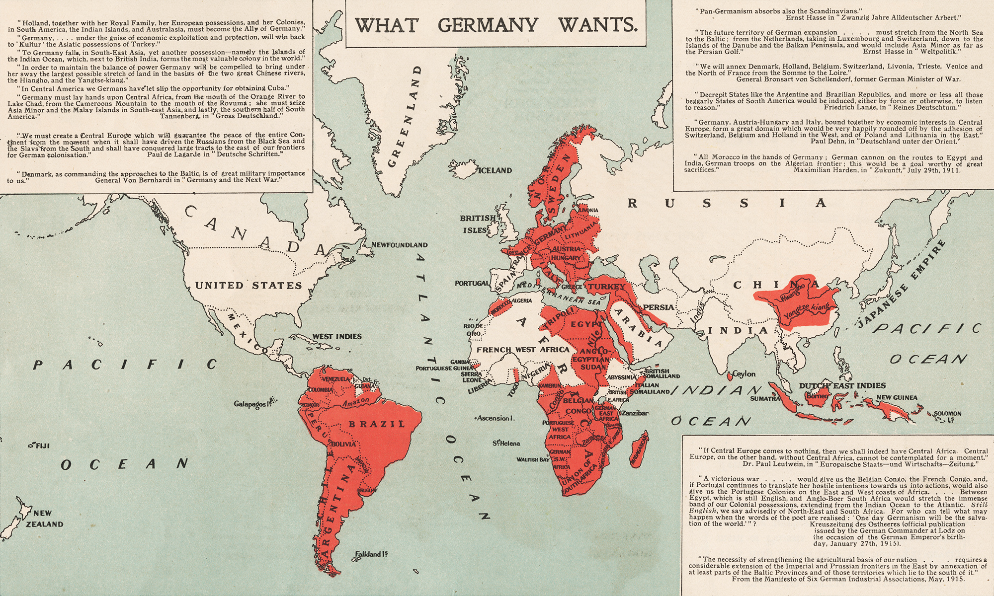
It wasn’t until the First World War that Westerns feared a single power might conquer the world. Allied propaganda, like this 1917 map, exaggerated Germany’s war aims. But in a foreboding of Hitler’s quest for Lebensraum in the East, Emperor Wilhelm II and his generals did seek territorial expansion in Eastern Europe as well as a “place in the sun” for Germany in the tropics.
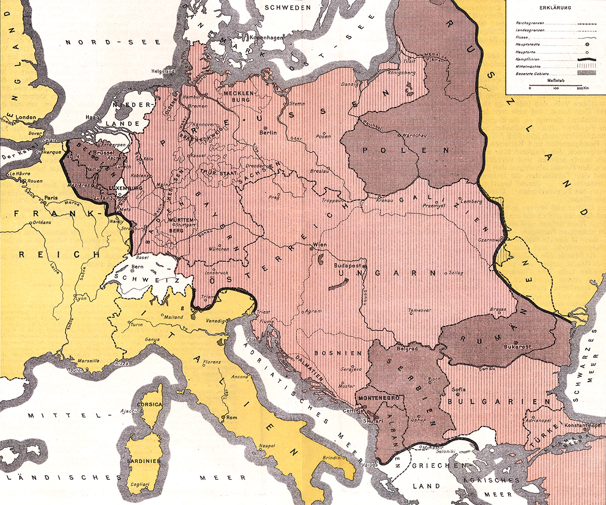
Wilhelm Greve, a German lithographer, came closer to mapping the true aspirations of Imperial Germany. In this 1916 map, the Alsace has been incorporated in the German Empire. Albania, Belgium, Poland, Romania and Serbia may be nominally independent but are really subservient to Berlin and Vienna.
Click here for more maps of a German victory in World War I.
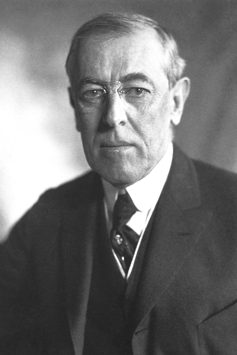
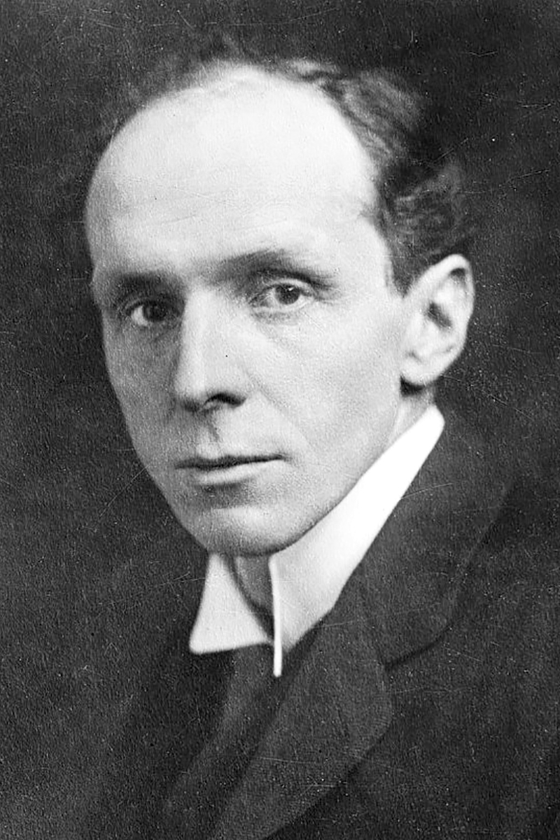
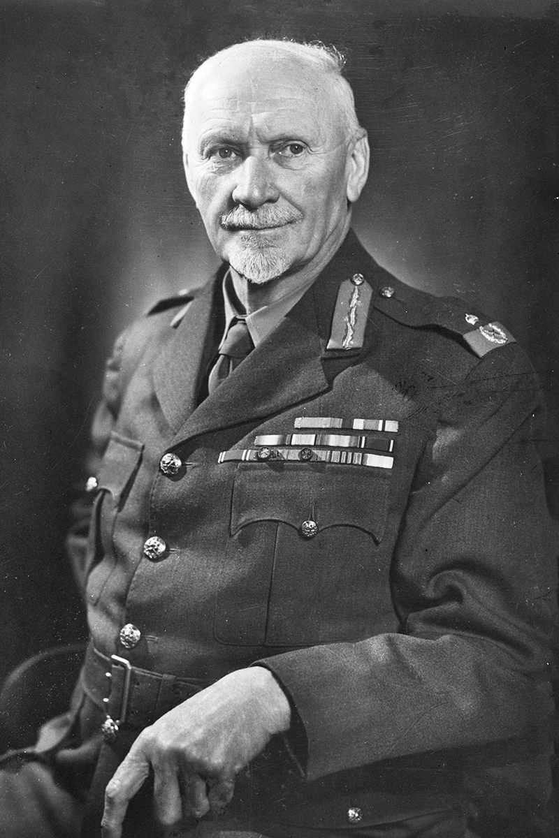
League of Nations
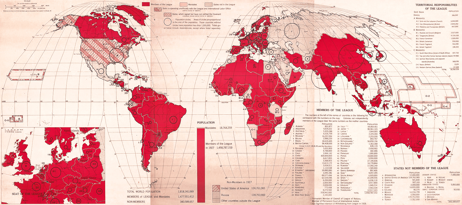
The horror of World War I — 40 million people died in four years — gave rise to the most serious attempt at global governance until then: the League of Nations.
The body is associated with wartime American president Woodrow Wilson, but one of his predecessors, Theodore Roosevelt, had called for an international “League of Peace” years earlier; Britain’s World War I-era ambassador to the United States, Lord Bryce, popularized the idea in America; and Britain’s Robert Cecil and South Africa’s Jan Smuts authored the Covenant of the League of Nations, which created the institutions of the league as well as mandates in the former colonies of the defeated Central Powers.
42 nations started the League. Six more joined during its first year. Argentina was the first nation to withdraw in 1921, when its proposal to admit all sovereign nations was rejected. Germany joined in 1926 and withdrew in 1933. The Soviet Union was admitted in 1934 but expelled in 1939 for invading Finland. America never joined.
At its peak, in 1934-35, the League had 58 members. Egypt was the last nation to join in 1937, but by then the organization had become irrelevant. It had failed to prevent Hitler’s land grabs in Europe, Japan’s war on China, Italy’s invasion of Abyssinia (Ethiopia) and foreign interference in the Spanish Civil War.
Soviet republics
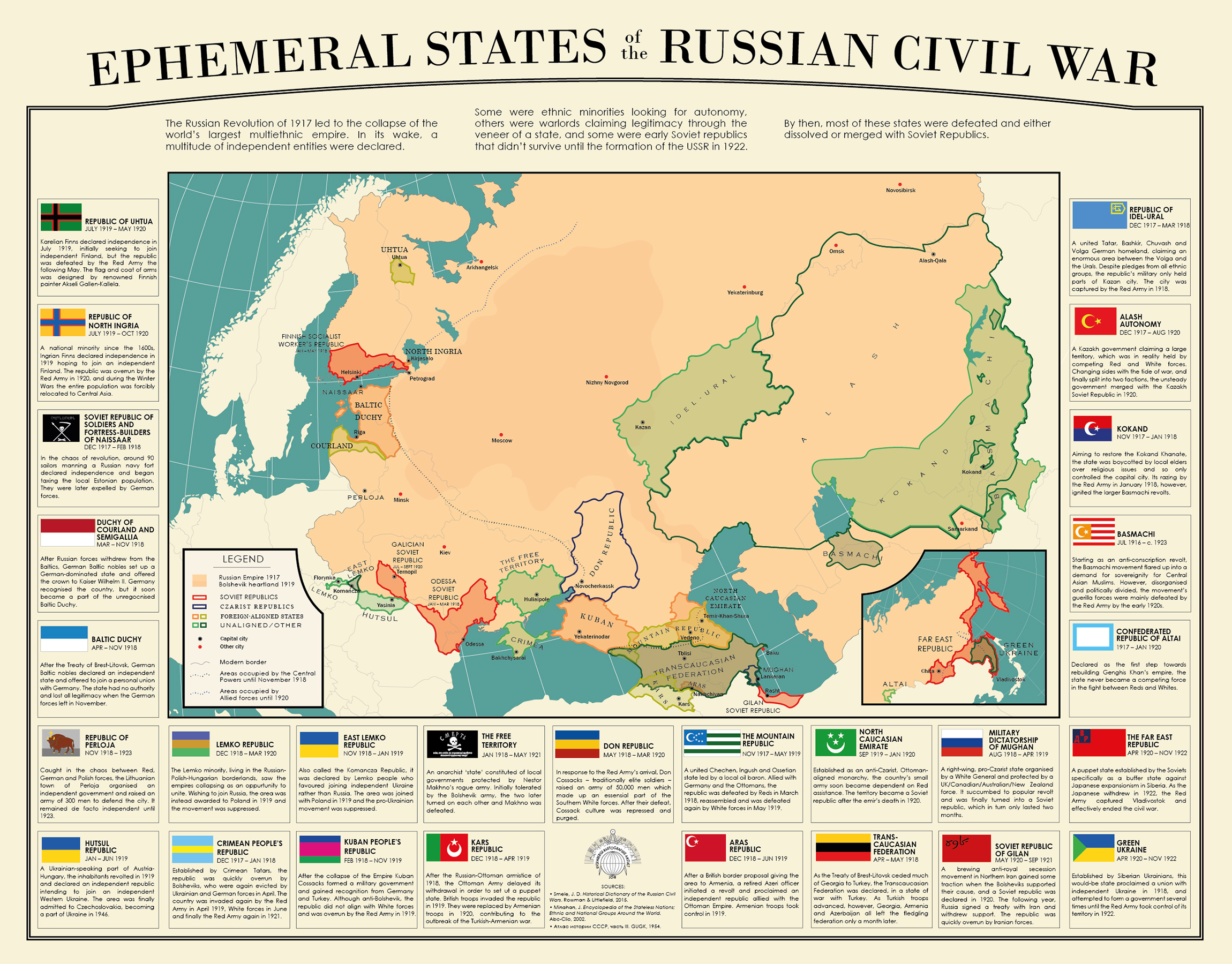
In the unrest and Civil War that followed the Russian Revolution of 1917, many states were proclaimed in the territory of the former Russian Empire. Some were ethnic minorities looking for autonomy. Others were warlords claiming legitimacy through the veneer of a state. Others yet were proto-Soviet republics that were later incorporated into the USSR. The above map shows most of these “ephemeral states” (which did not all exist at the same time).
Click here to read more.
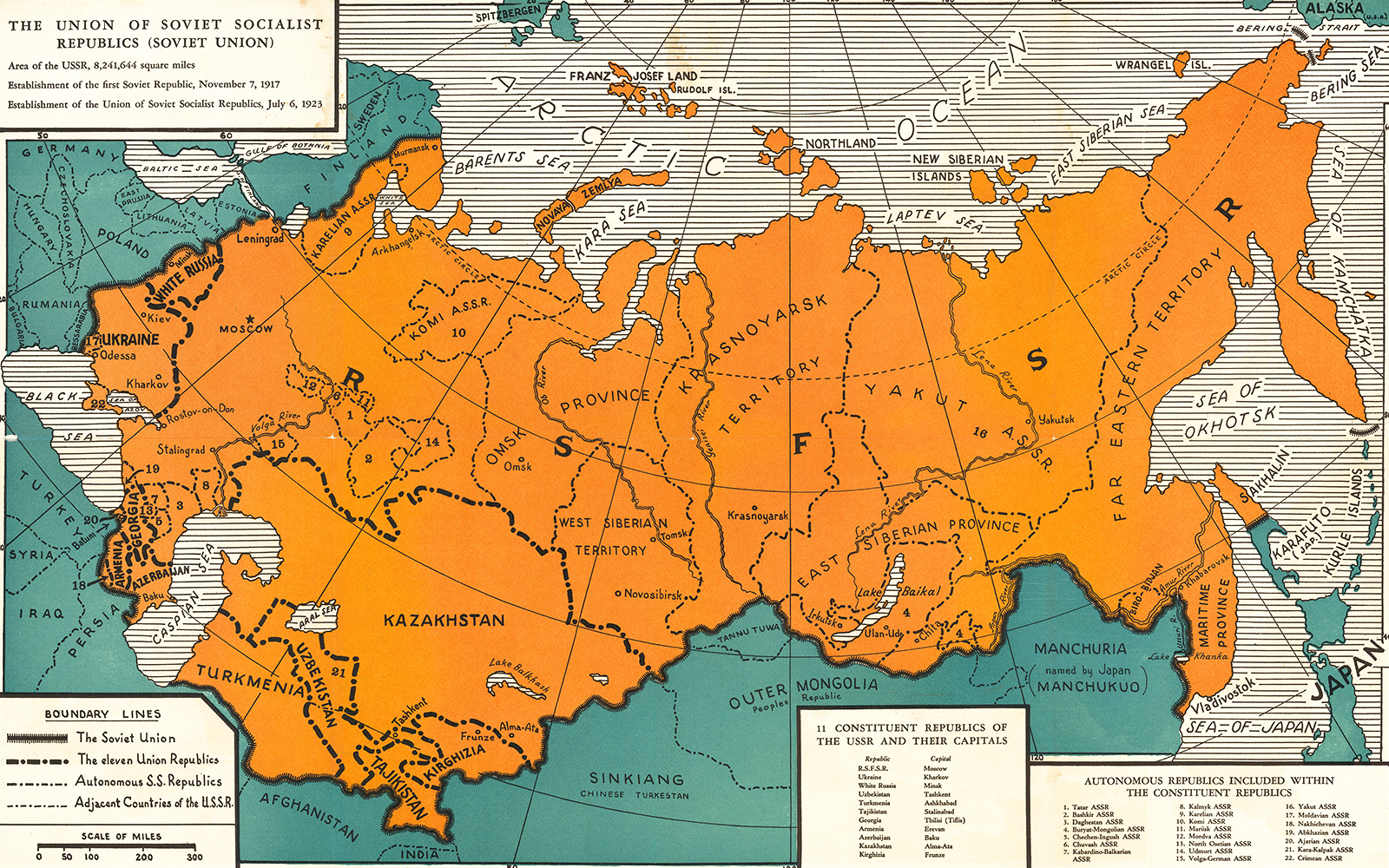
The USSR was formed in 1922 as a union of the Russian, Transcaucasian, Ukrainian and Byelorussian republics. The first three, in turn, contained autonomous socialist republics, which were often centered on non-Russian ethnicities. The union republics were theoretically sovereign and allowed to secede. In reality, all the republics were subordinate to Moscow.
In the beginning of the Soviet Union, there were genuine efforts to extend rights and autonomy to non-Russian peoples, who had been classified as “aliens” under the czar. Officially recognized ethnicities received their own cultural institutions, media and schools.
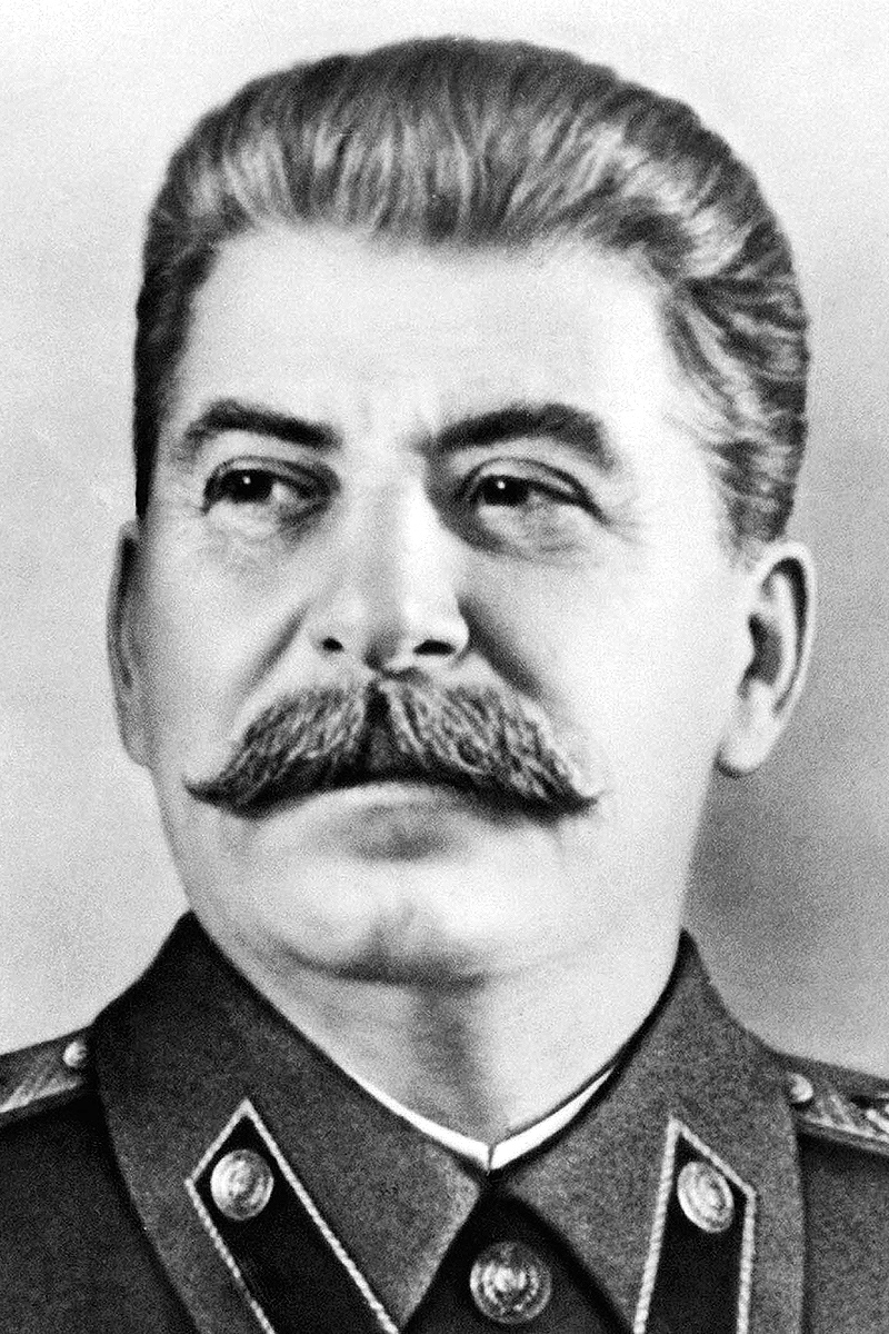
This changed under Joseph Stalin, who drew artificial boundaries to divide ethnicities and moved entire peoples around the Soviet Union in the name of Russification. Millions perished in population transfers to Central Asia and the Far East.
Tajik, Turkmen and Uzbek republics were created in the 1920s from the territory of the Bukharan and Khorezm People’s Soviet Republics. The Transcaucasian Socialist Federative Soviet Republic was broken up in 1936, and Armenia, Azerbaijan and Georgia were updated from autonomous to union republics.
That same year, Stalin created two more republics in Central Asia which had hitherto belonged to the Russian Soviet Federative Socialist Republic: Kazakhstan and Kirghizia. Estonia, Latvia, Lithuania and Moldova were conquered in 1940 and incorporated into the Soviet Union as republics. A Karelo-Finnish Soviet Socialist Republic, including territory taken from Finland in the Winter Was, was created that same year but abolished again in 1956.
Had Stalin opened a front against the Nazis in Norway and joined the war against Japan before defeating Hitler; had the Red Army advanced deeper into Germany and had Tito not broken with Moscow, it’s possible Finland and Poland would have been incorporated into the Soviet empire as union republics and Manchuria, Mongolia, North Korea, Norway, Sweden and Yugoslavia drawn into the Soviet orbit as satellite states.
Intermarium

The Intermarium (“between seas”) was a Polish proposal for the federalization of Central and Eastern Europe.
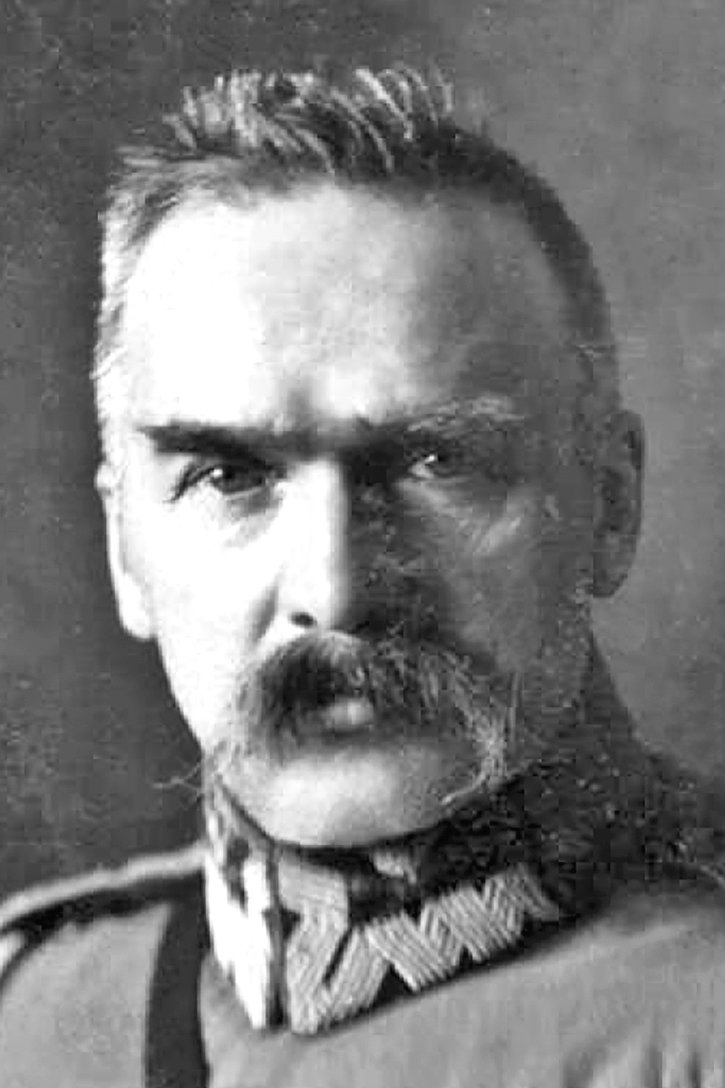
Poland’s post-World War I leader, Józef Piłsudski, was the most prominent proponent of the scheme, but it dates back to the early nineteenth century. Adam Jerzy Czartoryski, a leader of the 1831 Polish revolt against Russia, also supported it.
Outside Poland, the plan met little sympathy.
The Soviets opposed it, because they wanted the Baltic states, Belarus and Ukraine for themselves. The Western Allies were against it, because they assumed Bolshevism would eventually collapse and they still thought of Russia as a counterweight to Germany. Many of the federation’s prospective members saw it as a thinly-veiled attempt to resurrect the Polish-Lithuanian Commonwealth.
Twenty-first-century Poland has revived the idea of a strong Central Europe that can counterbalance both Western Europe and Russia in the form of the Three Seas Initiative.
Union of Central Europe
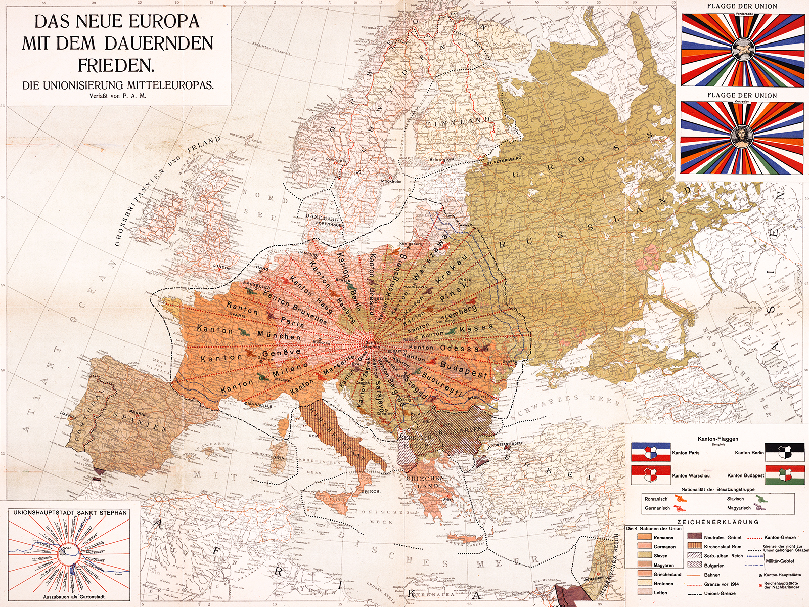
The Peace of Versailles had ended World War I but hardly resolved the ethnic tensions and territorial disputes that caused it.
P.A. Maas, probably the son of a Vienna-based printer named Otto Maas, predicted in 1920 that the peace would collapse and proposed in Das Neue Europa Mit Dem Dauernden Frieden. Die Unionisierung Mitteleuropas that “lasting peace” could come about through the “unionization of Central Europe”.
His European Einheitsstaates (Unity States) consisted of 24 Swiss-style cantons, each a long, narrow slice radiating from the union capital of Vienna. Each canton was named after a prominent city.
The union would recognize only four nations: Romans, Germans, Magyars and Slavs. Romans could be found in France, Italy and Romania; Germans in Austria, Bavaria, Prussia, the Low Countries, Saxony and Tyrol; Magyars in Hungary; and Slavs in Croatia, Czechoslovakia, Moravia, Poland, Ruthenia and Serbia. An elected presidency would rotate among the four nations. The official language of the union would be Esperanto.
Paneuropa
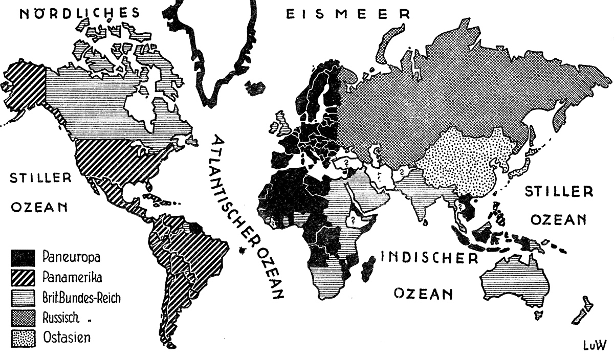
Richard von Coudenhove-Kalergi, a Bohemian nobleman, had a more realistic view of union in Europe. Together with Otto von Habsburg, the last crown prince of Austria, he founded the Pan-European Union in 1922, which called for the unification of Europe, in part to resist the threat of Soviet communism. Many of his proposals, including using Ludwig von Beethoven’s “Ode to Joy” as the European Anthem, were taken up after the Second World War.
Coudenhove-Kalergi’s ideas for the rest of the world did not see the light of day. He expected that European colonies in Africa and Asia would be incorporated in a European Union; that the United States and Latin America would merge into a Pan-America; and that China, Japan, Mongolia, Korea and Tibet would unite in a single East Asian state. Only Afghanistan, Ethiopia (before it was invaded by the Italians), Iran, Liberia and Turkey would remain independent.
Technocracy
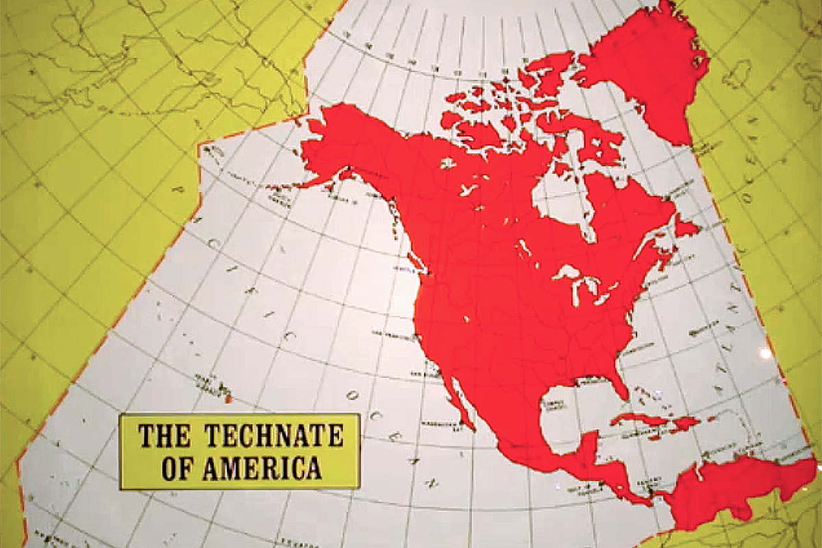
The Great Depression gave various new political philosophies a lease on life. Chile lurched to the far left. Brazil and Portugal turned to the corporatist right. Germany elected the Nazis. In Canada and the United States, the technocracy movement arose. It proposed replacing all politicians with economists, engineers, scientists and businesspeople.
Franklin Delano Roosevelt’s New Deal, which was also premised on expert control of the economy, took the wind out of the technocrats’ sails. In Canada, the movement was even outlawed.
The most prominent advocacy group was Technocracy Incorporated, founded by Howard Scott. It wasn’t very popular and — in what certainly didn’t bode well for their ability to govern — ridden by factionalism.
Their farthest-reaching proposal was to unite Central and North America into a “technate”, their argument being that the natural boundaries and resources of the area stretching from the Arctic to Panama made it “an independent, self-sustaining geographical unit.”
“Major Major”, a member of the Alternate History forum, imagines what a technocratic government of North America might have looked like. It’s not pretty.
English-speaking union
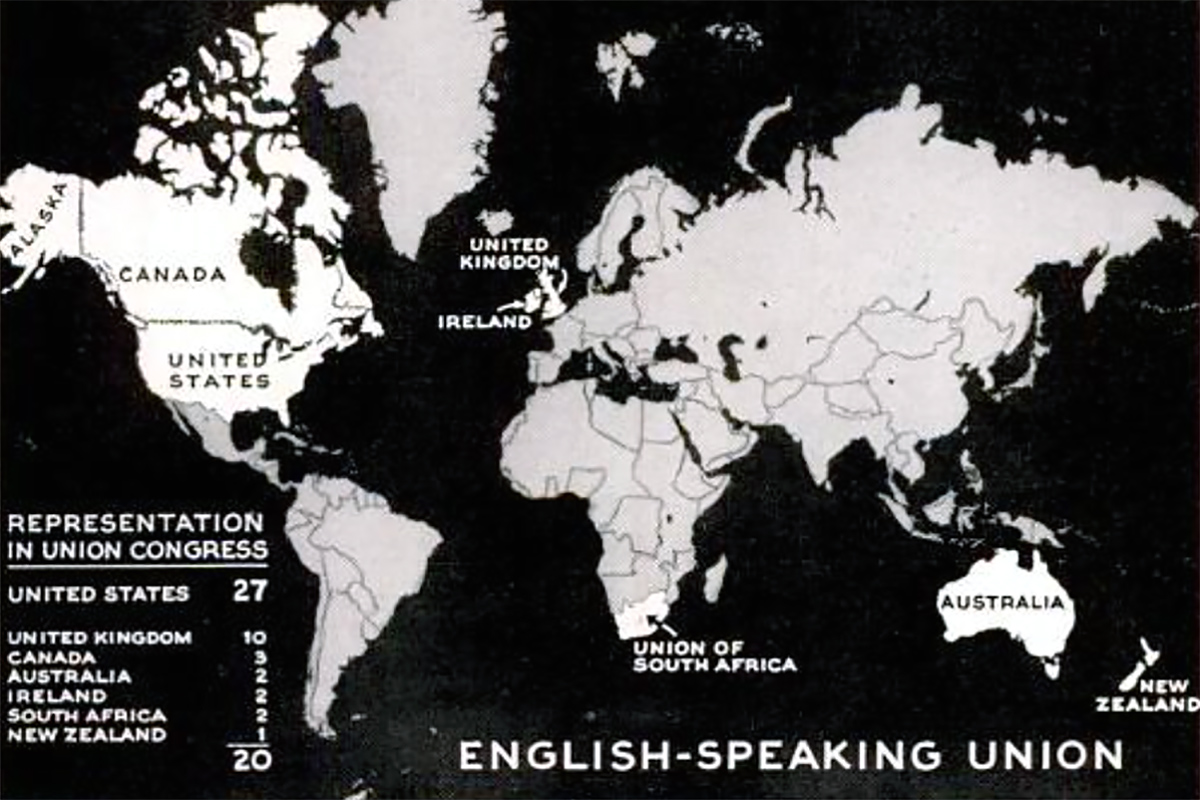
For British conservatives of a certain persuasion, the idea of uniting their country with its former white dominions and America has long had a special appeal.
Outside Britain, not so much. Few Americans, Australians or Canadians, much less the Irish and South Africans, have relished the prospect of an English-speaking union.
One exception was Robert E. Sherwood, an American playwright who would write speeches for President Franklin Delano Roosevelt during the Second World War.
Writing before the Russians entered the war on the Allied side in 1941, Sherwood feared a prolonged stalemate between Nazi-controlled Europe and the English-speaking free world. Isolated in a largely totalitarian world — “a world in which the term ‘cut-throat competition’ would mean just that” — America’s standards of living would be reduced, he warned readers of Life magazine. A union of the English-speaking peoples promised respite. Click here to learn more.
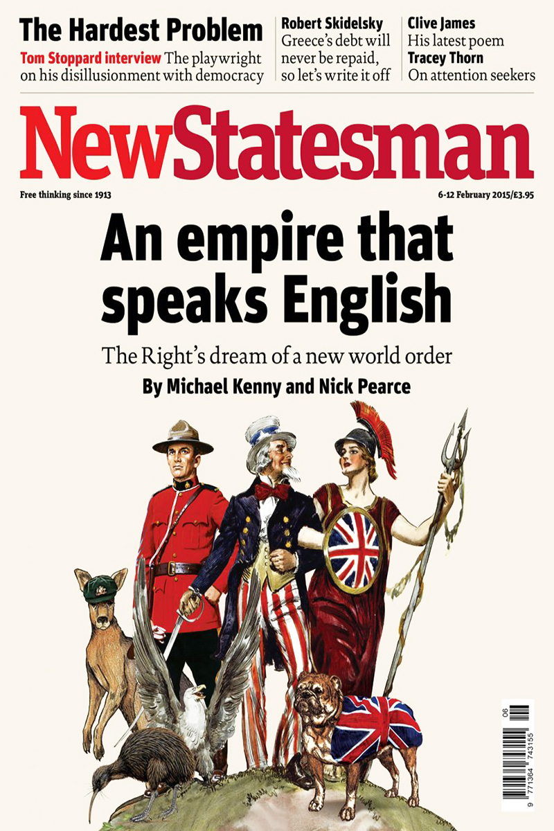
Britain’s exit from the EU has revived hopes of uniting the Anglosphere.
CANZUK, a proposed political and economic union of Canada, Australia, New Zealand and the United Kingdom, has support from right-wing politicians and think tanks in all four countries. It would contain some 135 million people and have a combined economic output of $6.5 trillion. Skeptics see it a resurrection of the “White Commonwealth”.
Allies versus Axis
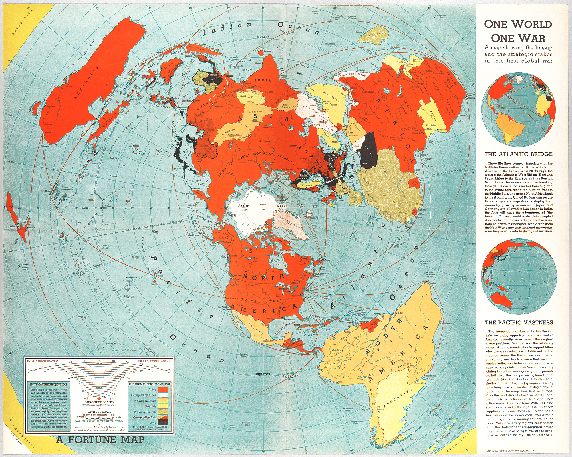
The 1914-18 Great War was global, with battles in Africa and Asia, but the bulk of the fighting was in Europe. World War II really was fought on every continent. The British and Germans sent troops to Antarctica; the Battle of the River Plate took place in South America).
This map by Richard Eden Harrison, published in Fortune magazine at the height of Axis expansion in 1942, shows almost the entire world at war. The only true neutrals are Argentina, Ireland, Portugal and its colonies, Sweden, Switzerland, Tibet, Turkey and Saudi Arabia. Argentina and Saudi Arabia eventually joined the Allies.
Hitler’s empire

Adolf Hitler dreamed of a German Empire stretching from the Atlantic Ocean to the Ural Mountains. The Japanese envisaged a Greater East Asia Co-Prosperity Sphere. The Western Allies planned the United Nations. The Soviets meant to push their borders as far west as possible. All sides imagined the world after the war would be different.
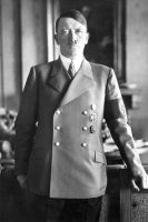
Historians still debate if Hitler was serious about world domination, but there is no doubt he wanted to withdraw the map of Europe. A Großgermanisches Reich (Greater Germanic Empire) would have covered Northern Europe and housed races deemed worthy by the Nazis, including the Dutch, Czechs and Nordics. Jews, Poles and Slavs were to be eradicated or expelled. Reichskommissariaten would have replaced countries.
Hitler’s plans for Europe south of the Danube were less clearly articulated, although the river itself would have played a major role in connecting historic Germany with its new colonies in the East. Albania, Croatia, Greece and Montenegro may have been left to Italy. Bulgaria, Hungary, Romania, Serbia and Slovakia would be ruled by Nazi allies or puppets.
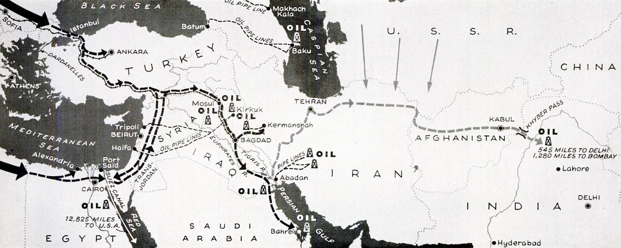
Hitler was sympathetic to the Arabs, who saw in Nazi Germany a potential ally against colonial Britain and France. Practical collaboration was limited, however. Turkish neutrality blocked a German invasion of the Middle East. The Axis encouraged a coup against the pro-British monarchy in Iraq but could do little when the British sent troops. Nor could Hitler stop Britain and the Soviet Union from deposing the neutral ruler of Iran, Reza Shah, in favor of his more pliable son, Mohammad Reza Pahlavi, despite the Iranians being considered pure Aryans in the Nazi racial hierarchy.

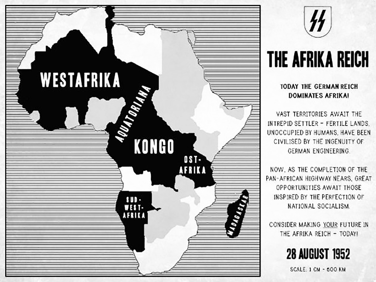
Africa was lower priority for the Nazis than Eastern Europe, but they looked forward to building an empire there too. The north would be left to Italy, so Benito Mussolini could have his New Roman Empire. White Afrikaners would rule Rhodesia and South Africa. In between, Germany would lord over Mittelafrika.
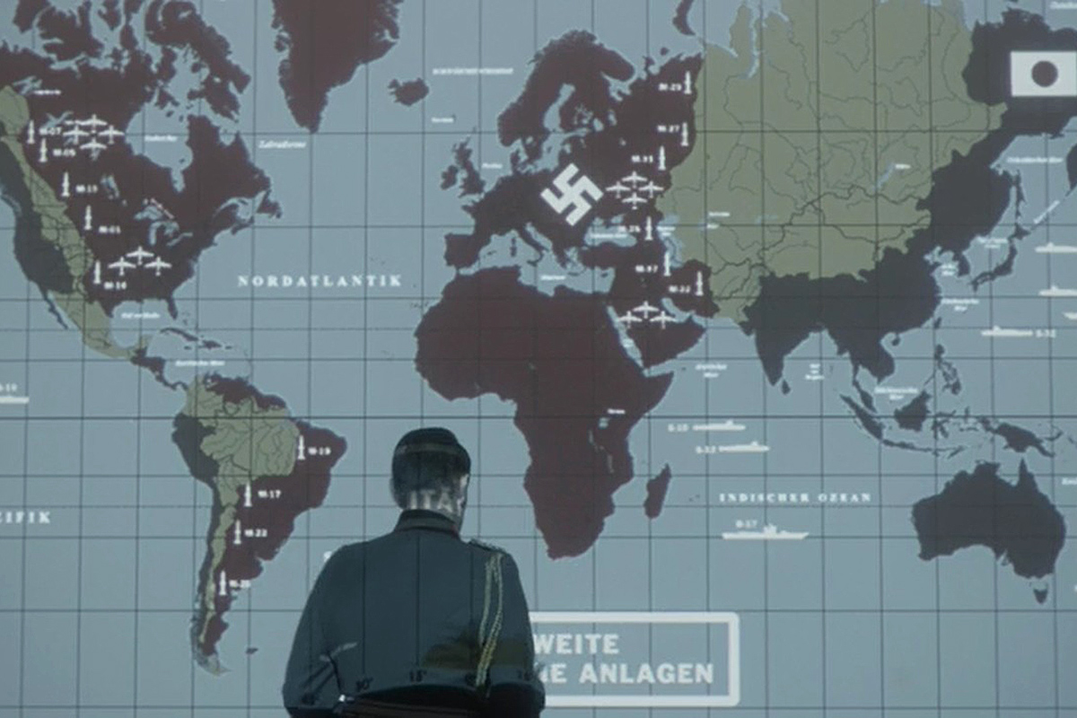
Amazon’s The Man in the High Castle (2015-19, our review here), based on the 1962 Philip K. Dick novel of the same name, gives us a glimpse of a world in which the Axis were victorious.
Germany (presumably with Italy) controls the Atlantic area, including all of Africa, Europe and the Middle East as well as the bulk of North America and the eastern half of South America. Japan has the Pacific Rim, including what used to be the American West Coast, parts of Central America, Chile and Peru.
Separating the empires, which are formally allied but really locked in a cold war, are the remnants of the Soviet Union in Eurasia, an unruly Neutral Zone in North America, Mexico and “Amazonia” in the middle of South America.
Click here to learn more about the world of The Man in the High Castle and here to learn more about a world in which the Axis won World War II.
Japan’s ambitions
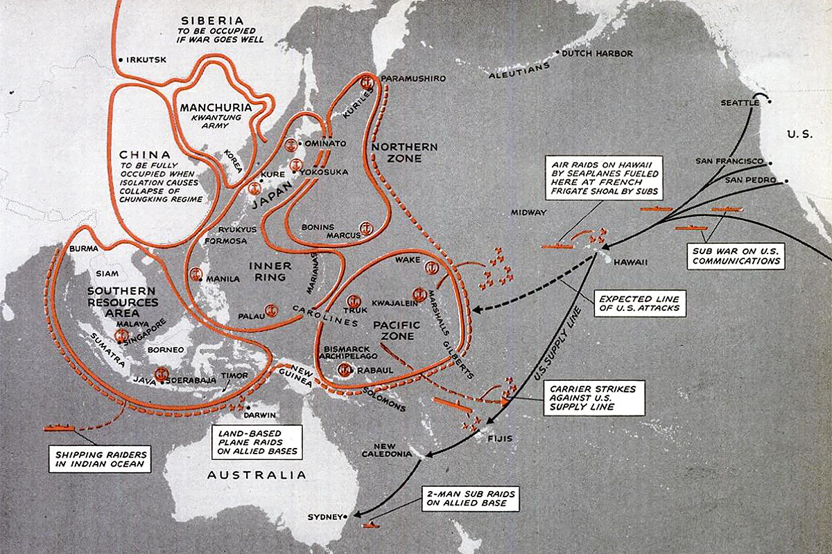
Japan’s ambitions never extended beyond Asia. Life revealed as early as December 1946 that the Japanese had had no plan to invade the continental United States. The attack on Pearl Harbor was only meant to immobilize the American fleet so the Japanese could take the Philippines, Guam, Singapore, the East Indies and Wake Island.
Then the Japanese thought they would have time, behind their outer defenses, to exploit their new “southern resources zone” for raw materials which they needed to complete their hopelessly deadlocked war in China.
Japan’s long-term goal was to establish a “Greater East Asia Co-Prosperity Sphere”. For some, this was an expression of anti-colonial and pan-Asian ideals. In reality, it was a vehicle for Japanese domination of East Asia, including the whole of China, India and what would become Indonesia.
Click here to see the rise and fall of Japan’s empire in maps.
Post-War New World
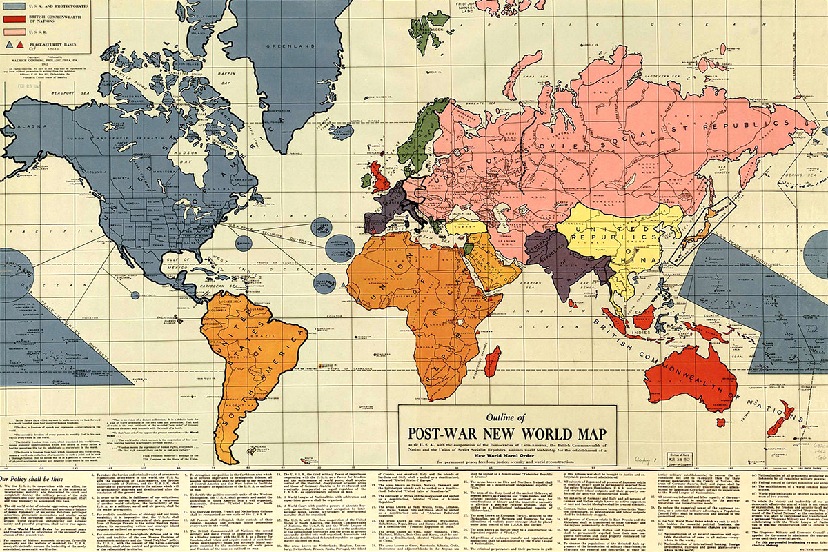
Maurice Gomberg of Philadelphia self-published this Outline of the Post-War New World in February 1942. He predicted a world pf blocs: the United States expanding to cover the whole of North America, the Soviet Union dominating Eurasia, and Africa, Europe and South America forming their own federations.
India, at the time under British rule, would become independent, but Gomberg for some reason gave Indonesia, which the Japanese had taken from the Dutch, to the Commonwealth.
Albania, Greece, “Hebrewland” (a Jewish state in Palestine and Transjordan), Ireland, Japan and Turkey are the only nations allowed independence.
Little is known about Gomberg, but that hasn’t stopped conspiracy theorists from imagining his map was America’s grand design to remake the world. It even hints at a “New World Order” in the title!
1984
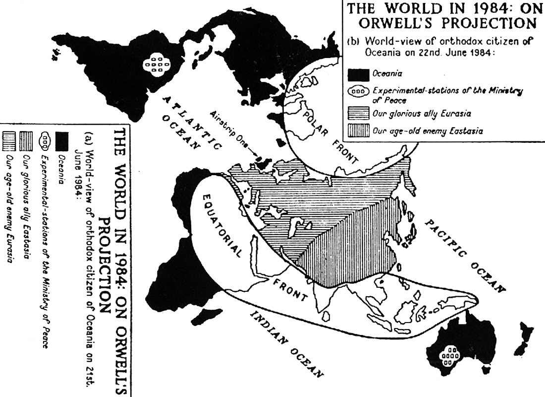
Small nations being swallowed up by superstates could end in permanent war rather than permanent peace.
In George Orwell’s Nineteen Eighty-Four (1949), three totalitarian superstates vie for world domination. Oceania, ruled by the Ingsoc party, consists of the Americas, Australia, British Isles and South Africa. Eurasia, governed by Neo-Bolsheviks, has continental Europe and the territory of the former Soviet Union. Eastasia, where the state ideology is obliteration of the self, includes parts of Central Asia, China, Japan, Manchuria and Korea.
The three states battle for supremacy on two fronts: a Polar Front, including Greenland and the northern reaches of Canada and Siberia; and an Equatorial Front, spanning from North Africa in the west to Indonesia in the east.
No state is strong enough to prevail on its own, but none is weak enough to lose against a combination of the other two either. Alliances constantly shift. Whenever Oceania changes sides, the censors of Ingsoc must quickly update all references to yesterday’s “age-old enemy” into today’s “glorious ally”. The above map makes it easy. Just tilt it 90° when Oceania changes sides.
Yalta

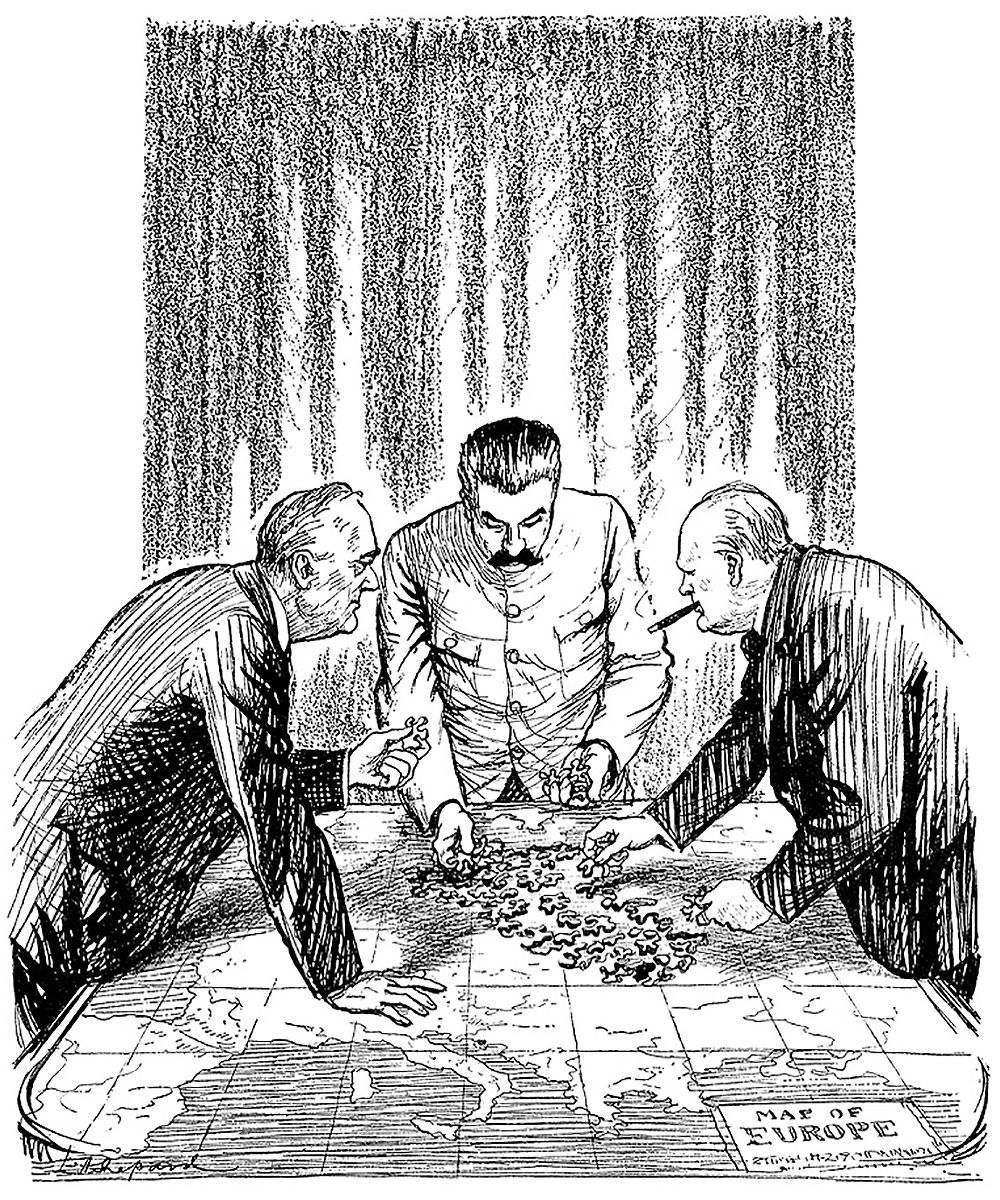
The reality of the post-World War II division of Europe was closer to Gomberg’s vision than Orwell’s. Stalin did push the Soviet Union’s borders as far west as he could. The continent’s remaining free nations united under American leadership.
The east-west split, which would condemn the nations of Central and Eastern Europe to almost half a century of authoritarianism, was formalized at the Yalta Conference of the three major Allied powers in February 1945 — three months before victory in Europe. Winston Churchill and Joseph Stalin had already agreed that Russia could maintain its position in Eastern Europe while influence in Hungary and Yugoslavia would be split. The fate of Poland and Germany had to be decided at Yalta.
Stalin, having seen to it that the Warsaw Uprising would be crushed by the Nazis before the Red Army liberated Poland, insisted on recognition of the communist-dominated Provisional Government rather than the democratic Polish government-in-exile. Stalin promised free and fair elections in Poland; that didn’t happen until 1991. The country was shifted west on the map: its so-called Eastern Borderlands were transferred to Russia while much of the former Prussia was given to Poland. Russia took East Prussia for itself, renaming it Kaliningrad.
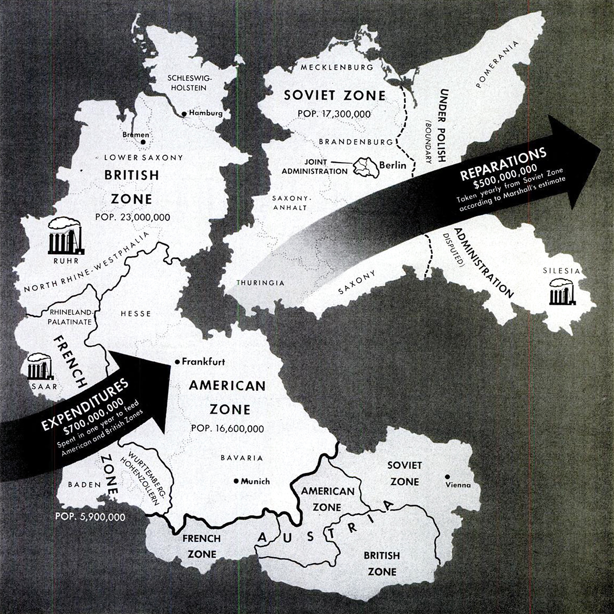
Various possible partitions of Germany were considered, including a three-way split, before the now-familiar east-west division was agreed. Click here to learn more.
Albania, Bulgaria, Czechoslovakia, Hungary, Romania and later East Germany were taken over by communists. Communists tried, and failed, to take Greece as well, but the American- and British-backed monarchists won the Civil War. Yugoslavia, under Tito, went communist but split from Stalin. After many of the remaining European nations joined Canada and the United States in the North Atlantic Treaty Organization in 1949, the Soviets created an equivalent organization, the Warsaw Pact. The stage for the Cold War was set.
United Nations
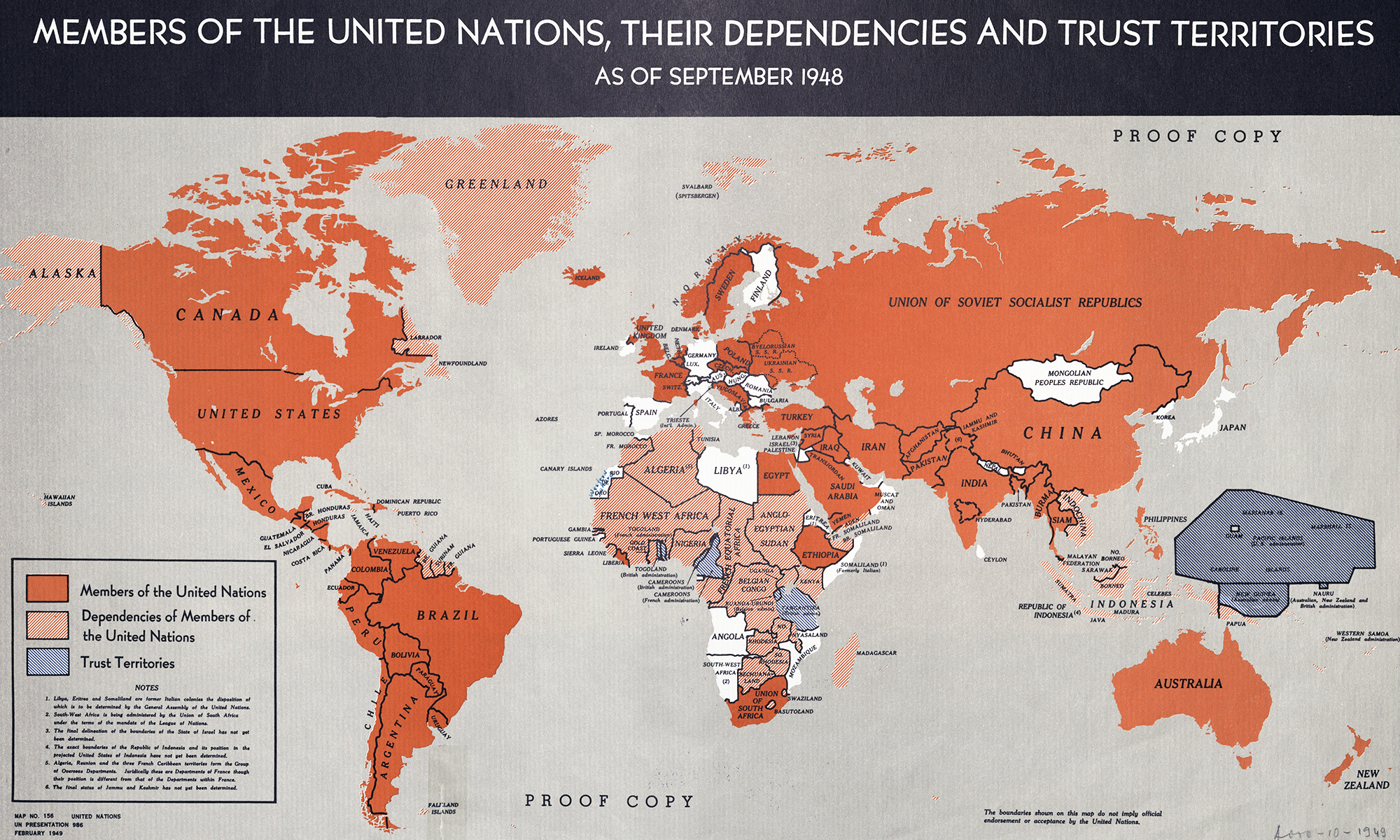
A more positive attempt to remake the world came in the form of the United Nations; a relaunch of the interwar League of Nations, which had so miserably failed to prevent another world war.
Rooted in the wartime anti-Axis alliance, the United Nations would be more effective than the League. It could make decisions by majority voting, rather than unanimity, and its five most powerful members — China, France, Russia, the United Kingdom and the United States — would police the rest.
That didn’t happen. Expectations that the five veto-wielding members would put the common good first proved unrealistic. After a promising start in the early years of the Cold War, with international peacekeeping missions to Korea, Suez and Congo, communist vetoes (Red China took Taiwan’s seat in 1971) prevented the UN from intervening in the Middle East, Vietnam and Kashmir. The organization increasingly focused on its ostensibly secondary goals of cultural exchange, economic development and humanitarian aid.
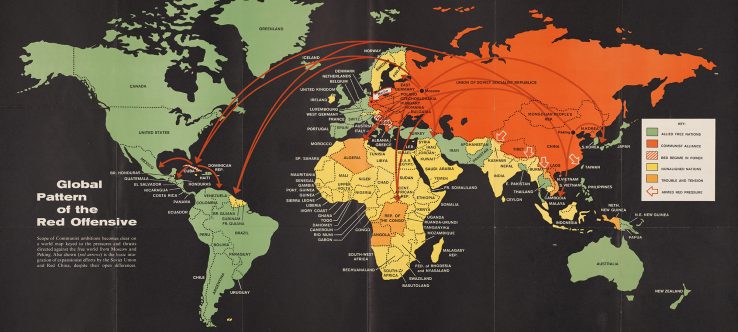
Cold War
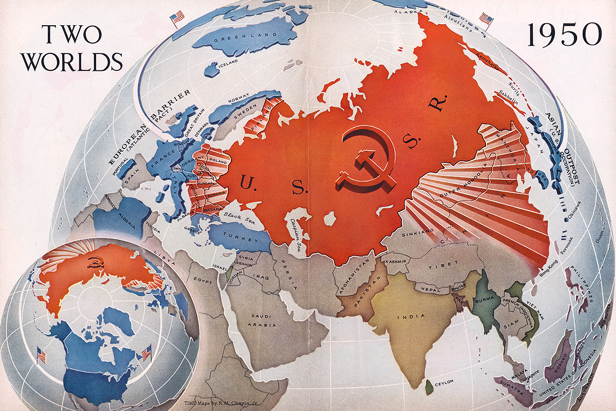
If the Second World War was the first truly global war, the Cold War that followed it was the first truly global competition between two states. Hitler may have dreamed of dominating the world; America and the Soviet Union had the means to. If not through direct conquest, then by economic and political influence.
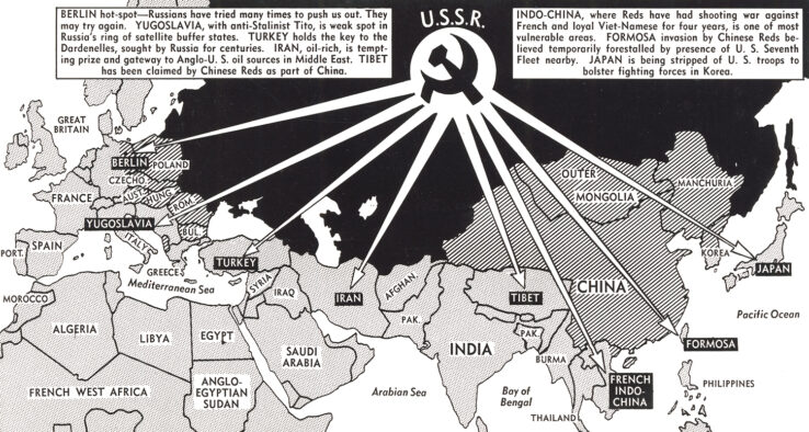
The West really feared the Soviets might start another war in the late 1940s and early 50s. Stalin, after all, had conquered the Baltic states and Moldova in 1940 and refused to leave Eastern Europe after liberating it from the Nazis. Red Army troops also remained in Iran. The Soviet Union financed communist parties in France and Italy, and armed communists in the Greek Civil War and the Korean War.
What the West didn’t know was just how vulnerable the Soviets felt; they, too, thought World War III was likely, except NATO would start it!
Tensions almost reached the boiling point in 1962, when the Soviets, believing themselves to be acting defensively against American missiles in Europe and Turkey, deployed nuclear-armed missiles to Cuba, which the Americans interpreted as an offensive action. The ensuing Cuban Missile Crisis really was the height of the Cold War in that the threat of nuclear war would never be more imminent. Intercontinental ballistic missiles and gargantuan nuclear arsenals had given both sides the ability to strike anywhere on Earth and destroy each other many times over. Starting World War III would be suicide. The acronym for this balance of power — mutually assured destruction — was not coincidentally “MAD”.
The superpowers settled into “peaceful coexistence”, although Soviet pragmatism caused a split in the communist camp with China insisting on continuing the world revolution. But this also gave the United States an opportunity to restore relations with Red China, which now regarded the neighboring Soviet Union as a rival.
Meanwhile, in the former colonial world, India and Indonesia led a bloc of countries that refused to align with either side in the Cold War. Where there had been “two worlds” in the 1950s, by the 1970s there were at least three, and any one power controlling the whole planet became a fantasy again.
Hyperpower
Another two decades later, one-power control of the world seemed possible once more. The Soviet Union had imploded, Russia was on its back and few imagined China would rival the United States economically in another twenty years. A British journalist coined the term “hyperpower” to describe (potential) world domination by the Americans.
The term resonated in France, where American power had long been regarded warily. “Hyperpower” was not a compliment.
But the concept was embraced by American hawks, who argued their country should seize the opportunity to remake the world. The height of this hubris was the Project for a New American Century, which called for increased defense spending during the peacetime of the 1990s to promote democracy and capitalism abroad, including by toppling regimes hostile to American “interests and values”. Some of the project’s luminaries — Elliott Abrams, Dick Cheney, Donald Rumsfeld, Paul Wolfowitz — were given a chance to put words into action during the George W. Bush Administration. Not only did their grand designs fail the first time they were put to the test; the catastrophe of the Iraq War accelerated the demise of American hyperpower.
World of blocs
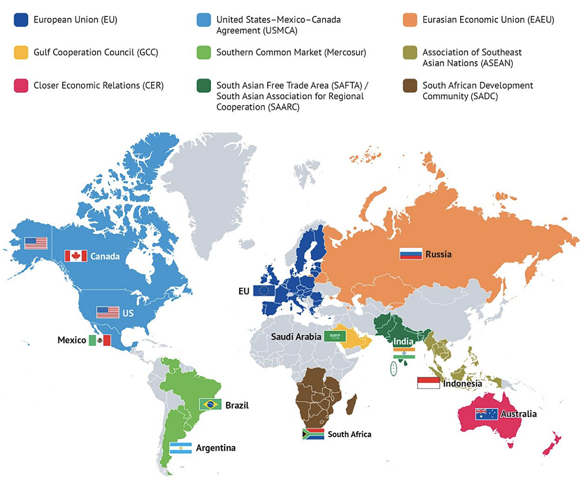
The above history should caution us against predicting the future too far out, but if I had to hazard a guess it would be that we’re moving into a world of blocs. The success of the European Union has inspired economic integration on every continent, from Mercosur in South America to the Association of Southeast Asian Nations.
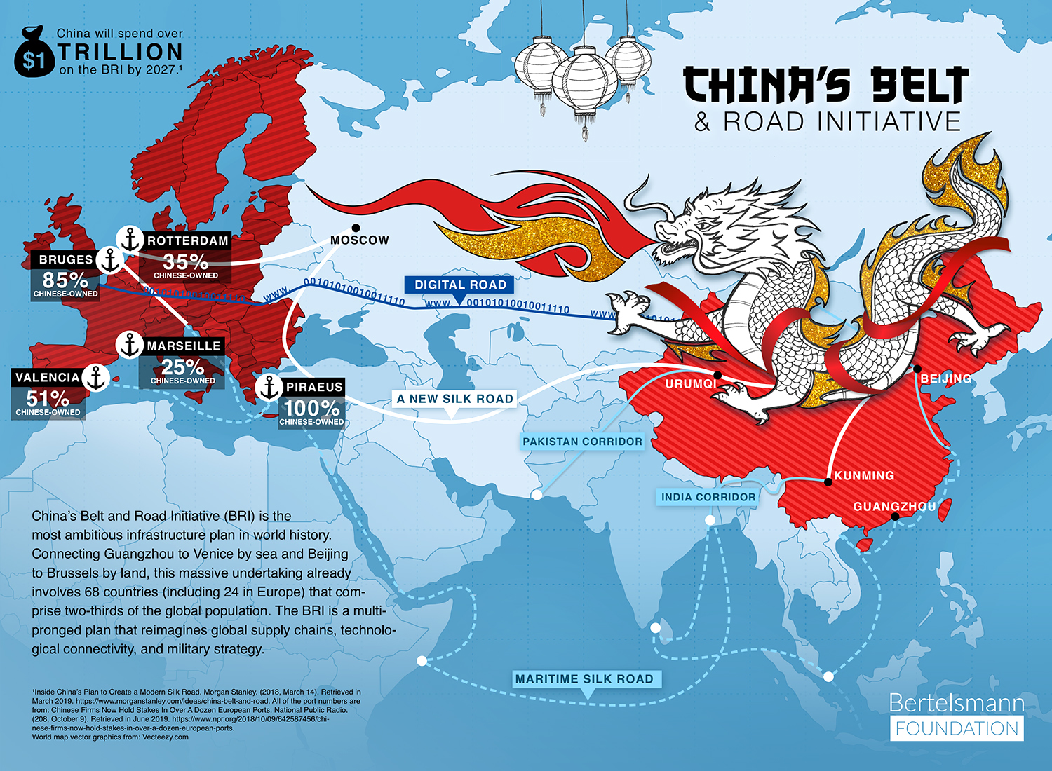
The beginnings of a Chinese bloc can be seen in the Belt and Road Initiative as well as the Regional Comprehensive Economic Partnership, China’s alternative to the Trans Pacific Partnership. Gomberg may get his way after all.


1 Comment
Add YoursIf you want to read about a successful attempt to remake the world, read Daniel Immerwahr’s *How to Hide an Empire: a History of the Greater United States*. The second half of the book is how the US made a world convenient for itself, with the English language and various technical standards and that sort of thing.