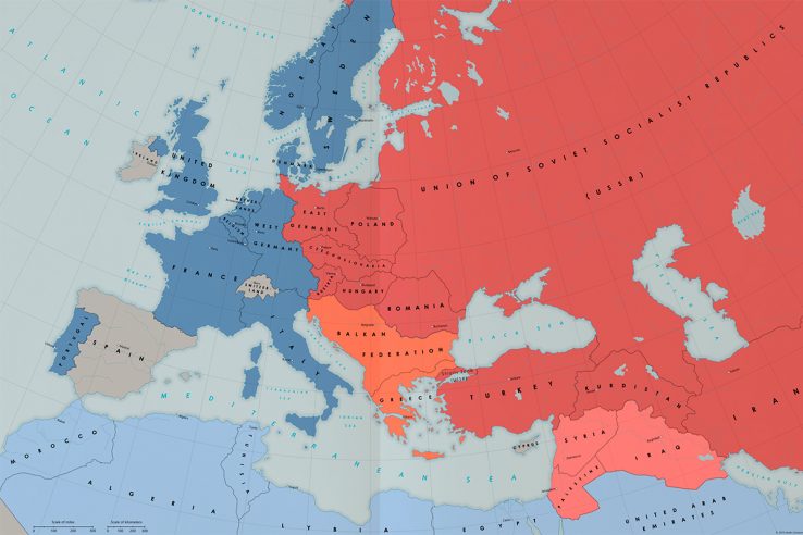
At a glance, this doesn’t look too different from your average Cold War map. Take a closer look, though, and you will notice some oddities. Half of Austria seems to be missing. East Germany is much bigger than it should be. Greece isn’t in NATO, but Sweden is.
What happened here?
The map, made by a Norwegian artist who goes by the name of Kuusinen, shows the Cold War in an alternate 1960.
Our point of divergence is the 1940 Winter War between Finland and the Soviet Union. Whereas the Finns were able to beat off the Soviets in our world, here they are defeated and Moscow installs a puppet government in Helsinki.
Later in the war, Soviet troops liberate Norway from the Germans and keep part of the country for themselves. The Red Army pushes deeper into northern Germany, seizing Schleswig and Holstein, which the Soviets add to East Germany after the war. They annex Finland and merge it with the Karelo-Finnish Soviet Socialist Republic, prompting a frightened Sweden to join NATO.
Austria and Germany are partitioned more or less as they were in our timeline, except Pomerania and Silesia are not ceded to Poland.
The status of Austria is not resolved as amicably as it was in the real world. The Soviet install a communist administration in their zone, leading the Western allies to add their Austria to the West German republic.
Yugoslavia liberates itself and establishes a federation with Albania and Bulgaria before Josip Broz Tito and Joseph Stalin part ways in 1949. The communists, aided by the Balkan Federation, win the Greek Civil War against the Western-backed monarchists. But the Soviets retain enough influence in Athens to halt its accession to the federation.
There are some interesting discrepancies in the Middle East as well, including the existence of an independent Kurdistan and the incorporation of Saudi Arabia in the United Arab Emirates.
Click here for the full story and a bigger version of the map.


