Many a what-if has been written about a German victory in World War II. Alternate histories of a German victory in World War I are less popular, but they exist. Indeed, people started thinking about the consequences of a German victory during the war itself and feared it might give way to a German empire spanning nearly the whole of Europe.
Here is a look at some of the maps that were produced to show the consequences of a German victory in what was at the time called simply “the Great War”.
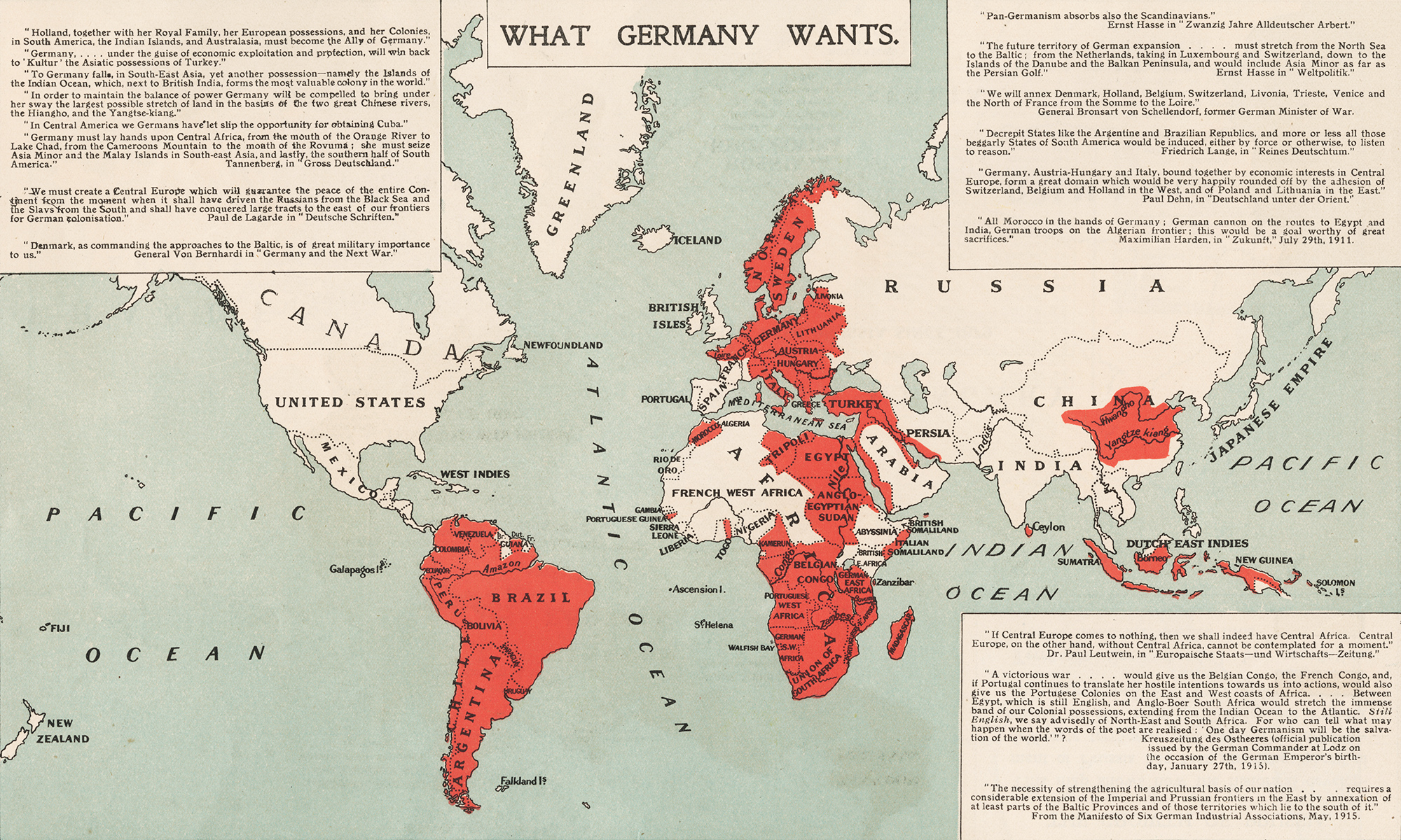
Morgen die Ganze Welt!
We begin with an alarmist map from 1917 (possibly 1918) that pulls together disparate quotes from a few military thinkers and quite a few more fantasists to argue that Germany’s war aims encompassed half the globe. It was clearly meant to cajole Americans into supporting the war and bore little relation to reality.
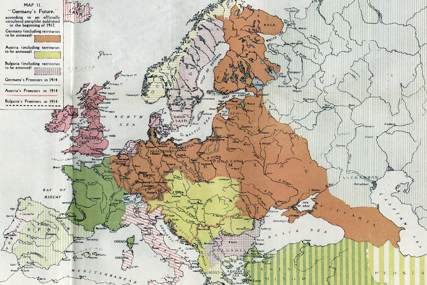
A German Europe
The British were less panicky, but this map published in The British Dominions Year Book 1918 still looks incredible in hindsight. It gives the Germans all of Eastern Europe, from Finland in the north to the Caucasus in the south, and has the Austrians seizing what are now Romania and Serbia.
The map doesn’t say where it got its ideas from except “an officially circulated pamphlet published in the beginning of 1917.”
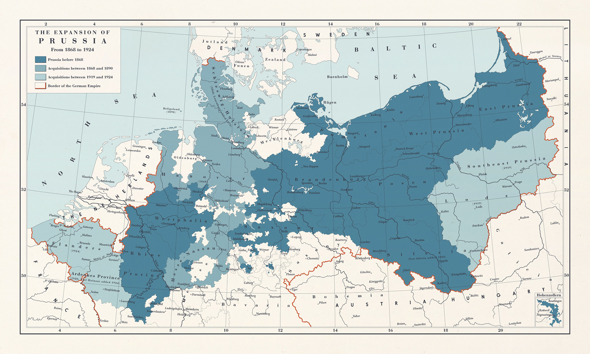
Greater Prussia
This looks more reasonable. It’s a map of Prussia as it would have continued to exist inside a victorious German Empire. The lightest-blue acquisitions are fictional: Flanders and an Ardennes Province in the west, where Belgium used to be, and a Southeast Prussia and Lodz in the east, in what is today Poland.
The map was made by a Swedish artist who goes by “1Blomma“. It assumes the 1918 Spring Offensive was successful and forced the French out of the war. The Germans would then have occupied the Belgian and French territories east of the Meuse River before seizing Flanders when it elected an anti-German government.
War aims in the West
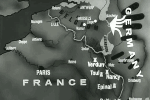
What if the infamous Schlieffen Plan — which proposed to trap the French armies between the Atlantic coast and their fortresses on the German border by attacking through neutral Belgium — had worked? (Some military historians in Germany contended after the war it could have if only Helmuth von Moltke had stuck with the plan. More recent analysis suggests it was doomed from the start.)
Chancellor Theobald von Bethmann-Hollweg set out Germany’s war aims in 1914 in the so-called Septemberprogramm. The purpose was to weaken France to such an extent that it could never wage war on Germany again. All fortifications in a zone running from Dunkirk in the west to Boulogne in the east were to be razed. Germany would seize the iron mines at Briey and force a commercial treaty on the French for the benefit of its own enterprises.
Belgium was to be partially incorporated into the German Empire; Luxembourg was to be annexed outright. The Netherlands would remain independent but brought into the German fold. Perhaps, Von Bethmann-Hollweg suggested, Antwerp could be given to the Dutch in exchange for a customs union and an alliance?
Vassals in the East
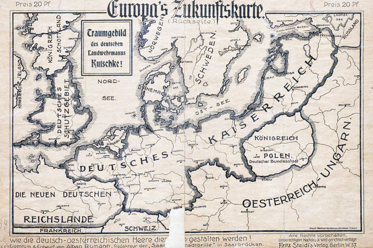
This 1915 propaganda map gets plenty wrong. There was no German plan to occupy England, for example, nor one to restore an independent Scotland. But the Baltic and Polish parts get close to the truth.
In the 1918 Treaty of Brest-Litovsk, the new Bolshevik government in Russia ceded the Baltic states and what used to be Poland to Germany. The plan was to turn them into vassals under German leadership.
The treaty also recognized an independent Ukraine, which the Germans planned to carve up into spheres of influence with Austria.
The Germans toyed with annexing the Crimea and creating new states in the Caucuses. The emperor’s youngest son, Prince Joachim of Prussia, was briefly considered a candidate for the throne of Georgia after it declared its independence from Russia in 1917. But no serious plans were made for this and nothing came of it.
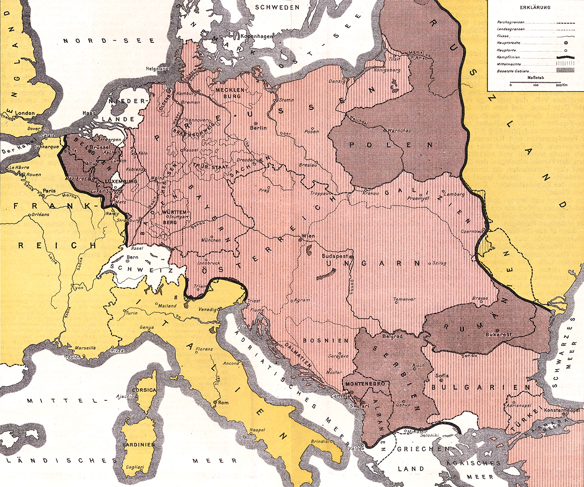
Central European empire
Germany had its own propagandists dreaming of a great victory in Central Europe.
The above map, by Wilhelm Greve, was published in Berlin in 1916. It shows a “liberated” Flanders, France’s northern provinces under occupation and Germany in control of the left bank of the Rhine.
In the Balkans, Albania, Montenegro, Romania and Serbia are occupied, as is Poland. The rest of Central Europe has been incorporated into the Austro-Hungarian Empire. Russia has lost some 285,000 square kilometers of its territory.
Central Powers take over America
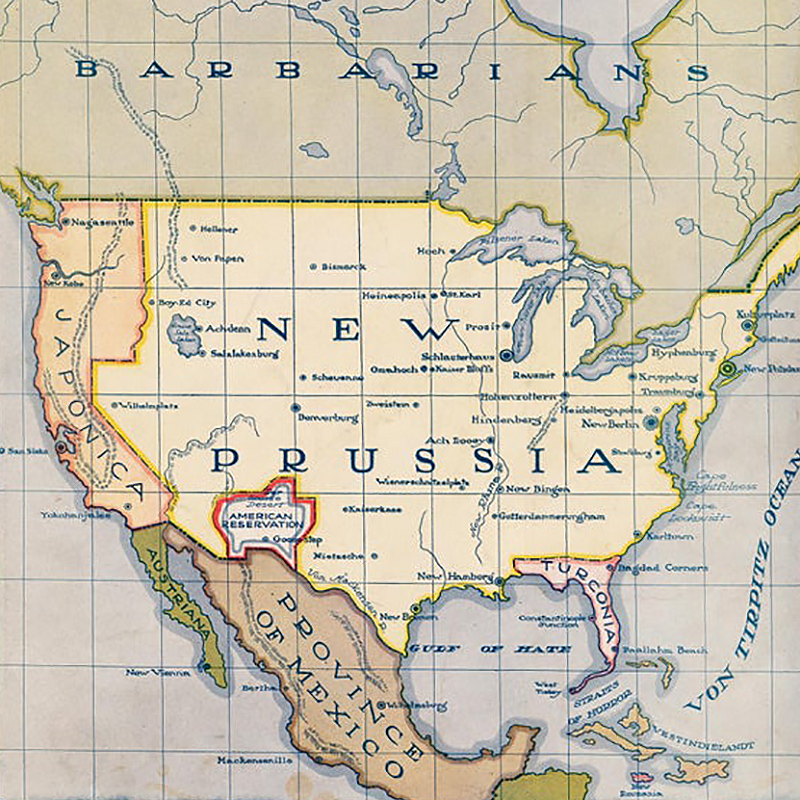
Life magazine speculated in February 1916 what might happen if the Central Powers prevailed in Europe and then set their sights on North America.
The magazine predicted the bulk of the United States would be annexed by Germany and called New Prussia. Cities would be renamed as well: Washington DC would become New Berlin. Florida would be split off and given to Germany’s ally Turkey.
Life envisaged that the West Coast would go to the Japanese. Odd, since Japan was on the Allied side in World War I. A reservation for Americans would be set aside in what used to be (and luckily still is) New Mexico.
Note that Canada is labeled “Barbarians”. Presumably the British Empire would have been defeated globally to make a Central Powers invasion of America possible.
Dismemberment of an empire
In reality, Germany lost about a tenth of its population and territory in Europe after the war: Alsace-Lorraine was returned to France after forty years of German control; Denmark received Northern Schleswig; Poland got parts of Silesia and West Prussia; Hlučínsko was transferred to newly-created Czechoslovakia.
This 1936 map, which was published in German schoolbooks, shows the territorial losses in red and those parts of Germany that were demilitarized under the Versailles Treaty in stripes. What the map calls a “diktat” also established freedom of navigation on Germany’s major waterways, which are highlighted in green: the Danube, Elbe, Oder and Rhine Rivers.

Germany’s peaceful penetration
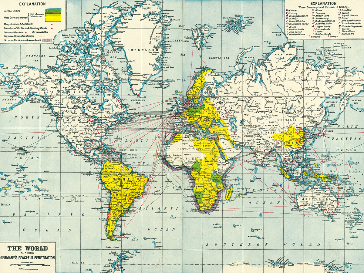
Despite Germany’s defeat in the war and the dismemberment of its empire, the Western world continued to watch it warily.
This 1920 map warns that Germany is outselling Britain in everything from machine parts to children’s toys and that it is peacefully penetrating non-German parts of the world “with elements of [its] spiritual and material culture.” The Germany of tomorrow “will remain a menace,” according to the mapmakers, “because vanquished Germany will renounce neither her ambitions nor her methods.”
The map alleges that Germany is eying control of Eastern Europe and almost the entirety of Africa and South America, yet when it comes to areas with German population it oddly leaves out the United States, which had the largest German minority outside Europe.